Whether it’s a Multi-Layered Survey/CAD Drawing File (Level-A), a mid-range Tie down Utility Markings to client provided site plan (Level-B), or the basic Color coded Single-Layered Drawing (Level-C), we’ll provide the detail you need at a price that is competitive and commensurate to your project’s specific needs. Whatever detail you need, we can record and compile the data in the form that is most beneficial to your needs throughout any or all phases of the building project.
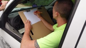
Josh sketching data map in truck

Taking a quick break from mapping a project
Watch this overview of the Data Mapping process. How it can benefit your project.
</p> <h4><b>Level-C Single Layer Scaled Drawing</b></h4> <p>

</p> <h4><b>Level-C Single Layer Scaled Drawing</b></h4> <p>

Underground Utility Data Mapping Service
Depending on the detail and complexity of the project we can provide client’s with custom map of all or a portion of your specific project. We can create a basic Utility Map drafted by hand or a more advanced version where our field technicians gather the data as their designating and locating the utilities and our survey/CAD technicians team uses advanced software to provide the most precise data delivered in the format of your choosing. We will use one or more of the following tools and techniques:
- field data
- field sketches
- notes
- drawings
- test pit forms
Some of our research data includes retrieving as built construction drawings, using field information to produce site plans, utility composite maps, and profiles.
Underground Utility Data Mapping Options
Utilities Search will attempt to preserve utility information revealed during the utility investigation according to the client’s budget and desired level of detail. When more specific location detail is required, our Underground Utility Data Mapping Service is implemented. Utilities Search, Inc provides Level-A, Level-B, and Level-C Data Mapping Service.
- Level-A — Multi-Layered Survey/CAD Drawing File
- Level-B — Tie down utility markings to client provided site plan.
- Level-C — Single Layer Color-Coded Scaled Drawing
Subsurface Equipment & Software used
The following is a list of the most common equipment and software we use to service the underground utilities locating needs of our clients.
- Auto CADD
- Micro Station v8

- Terra Model
- Carlson 3d
- ArcGIS
- Top Con Robotics
- Trumbar Robotics
More Services
Utility Locating • Utility Designating
If you are in the initial design or civil engineering phase of your project we will locate underground utilities using electromagnetic, geophysical and sonic methods to locate underground utilities and structures.
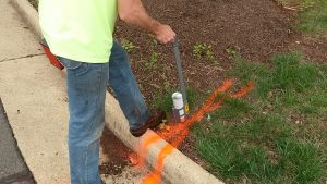
Marking / Designating Underground Power Lines
Air Vacuum Excavation Test Pitting
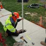
Air excavation provides us a non-invasive and non-destruction excavation system. After we designate and locate the underground utilities, air vacuum excavation test pitting allows us to precisely determine the exact location and depth of the buried utility cable, tank or structure. The excavation is able to expose utility lines with complete safety. The test pit is usually an 8” by 8” cut. The air probe breaks up the soil and the vacuum system uncovers the utility. Soil and surface cover is restored to its original condition.
Air Vacuum Excavation Test Pitting –
measuring pipe size, depth & position